WESTMINSTER, CO - DigitalGlobe, a Maxar Technologies company (NYSE: MAXR) (TSX: MAXR), today announced that it has signed a three-year extension of its existing EnhancedView Service Level Agreement (SLA) with the U.S. National Reconnaissance Office (NRO), reinforcing...
Moovit to Provide Public Transit Data for Microsoft Azure Maps
SAN FRANCISCO - Moovit, the world’s largest urban mobility data and analytics company and #1 transit app, today announced it will integrate its public transit information to Azure Maps to help developers build richer apps for billions of commuters around the world....
Spatial.ai Taps Industry Veteran To Launch World’s First Geosocial Dataset
CINCINNATI - Spatial.ai is proud to announce Darren Rose as Chief Revenue Officer. A location data veteran and no stranger to startups, Darren was employee number 10 at Millennial Media, helping to take them from startup to a $2B IPO. He later joined Adelphic as...
Seek Thermal Debuts New Handheld Thermal Imagers for Commercial Trade Professionals
SANTA BARBARA, Calif. -Â Seek Thermal today announces its Seek Shotâ„¢ and Seek ShotPROâ„¢ - two powerful handheld thermal cameras built for commercial trade professionals. A previously cost-prohibitive technology, thermal imaging is becoming widely adopted by home...
Trimble Introduces Satellite-Based RTX Corrections to the Kestrel Seismogeodetic System for Earthquake, Volcano and Infrastructure Monitoring
LAS VEGAS - Trimble (NASDAQ: TRMB) announced today the addition of Trimble RTX™ technology delivered via satellite to its Kestrel™ seismogeodetic system. Pairing uninterrupted, high-quality Global Navigation Satellite System (GNSS) positioning corrections with...
Hexagon's Geospatial Division Supporting the SIDE II Contract in the European Union
NORCROSS, Ga.– Hexagon’s Geospatial division announces that it is now an approved supplier for the Software for Innovation, Diversity and Evolution II (SIDE II) contract in the European Union (EU). Hexagon is now capable of helping EU agencies to best embrace...
Geospatial Expert Dan Wobbe, PLS, PIC, Joins Cardno’s Portland Office
Portland, OR - Cardno, Inc., is pleased to announce that Dan Wobbe, PLS, PIC, has returned to the firm as Regional Manager in the company’s Portland, OR, USA office. Dan brings over 30 years of surveying experience in areas such as boundary, location, construction,...
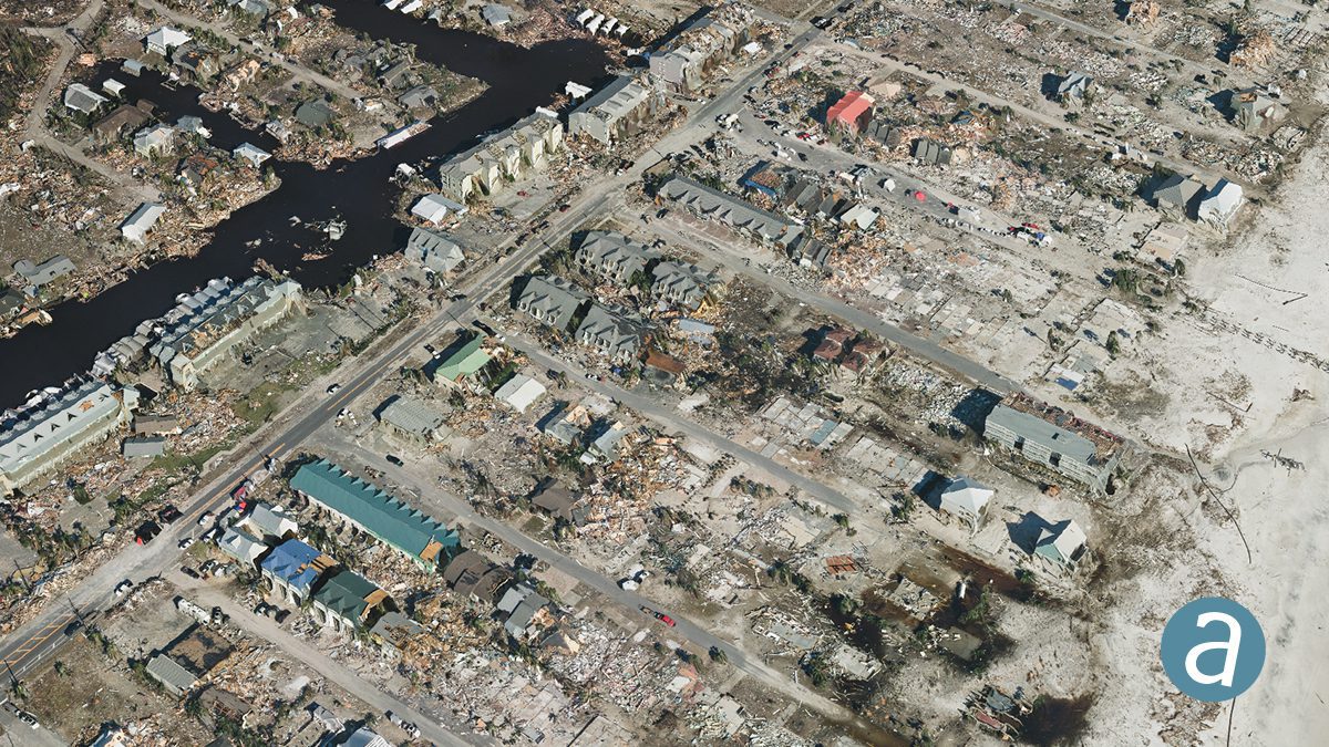
Remote Sensing Performs Damage Assessment following Hurricane Michael
SimActive Inc. partnered with Midwest Aerial to perform damage assessment of Hurricane Michael.
SimActive and Midwest Aerial Perform Damage Assessment following Hurricane Michael
Montreal, Canada, November 6th, 2018 – SimActive Inc., a world-leading developer of photogrammetry software, has partnered with Midwest Aerial to perform damage assessment of Hurricane Michael. Correlator3DTM was used to process large format imagery collected by...
Trimble Introduces Satellite-Based RTX Corrections to the Kestrel Seismogeodetic System for Earthquake, Volcano and Infrastructure Monitoring
LAS VEGAS - Trimble (NASDAQ: TRMB) announced today the addition of Trimble RTXâ„¢ technology delivered via satellite to its Kestrelâ„¢ seismogeodetic system. Pairing uninterrupted, high-quality Global Navigation Satellite System (GNSS) positioning corrections with...
