By James. S. Blundell, vice president, Geospatial Products and Solutions, Overwatch Systems (http://www.overwatch.com/), Sterling, Va.
Remote sensing, in all its varied forms and functions, has continually evolved, from the Civil War-era fixed balloons with spotters to modern unmanned aircraft systems that provide real-time situational awareness to warfighters in Iraq and Afghanistan. In today's world the geospatial community has a wide array of Earth observation choices, from multiresolution synthetic aperture radar (SAR) and multiband electro-optical (EO) imagery to high-resolution light detection and ranging (LIDAR) technology.

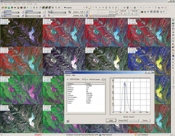
Figure 1. A multispectral analysis display window in Overwatch Systems' RemoteView 3.2 software provides analysts with enhanced visualization capabilities for new commercial satellite data, such as DigitalGlobe's 8-band WorldView-2 imagery.
These exciting remote sensing capabilities support topographic mapping, change detection, natural resource monitoring and many other applications that link remote sensing data with sophisticated geographic information system (GIS) software. To leverage the growing benefits of remote sensing, however, the geospatial community must provide its workforce with the appropriate tools and training to exploit the new high-resolution spectral and spatial data.
Technology Transfer
For example, the National Geospatial-Intelligence Agency (NGA) understands today's needs for image analysts to consume a wide range of remotely sensed data to produce timely and actionable intelligence. Areas of interest include the use of SAR data for advanced geospatial intelligence, merging full-motion video (FMV) data with traditional overhead satellite imagery, automated extraction of 3-D terrain and cultural features from LiDAR, and enhanced visualization of spectral information beyond the visible portion of the spectrum (Figure 1).

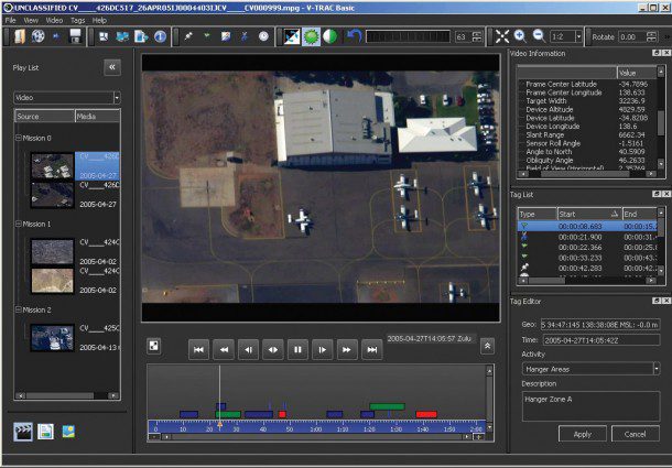
Figure 2. A complementary FMV toolset called V-TRAC Basic is provided to every domestic RemoteView Pro user, enabling analysts to conduct basic FMV analysis within the image analysis software.
To fill these needs, NGA routinely turns to the commercial sector for the expertise it needs. With a Cooperative Research and Development Agreement (CRADA), made possible by the Federal Technology Transfer Act of 1986, NGA can structure multiyear contracts with companies. For example, Overwatch Systems is helping the agency create data fusion solutions through a five-year CRADA.
A key objective in fusing tactical remote sensing data, such as FMV, with strategic national technical means and commercial imaging satellite assets is to develop a workflow that closes the gap between tactical and strategic intelligence collection. As a result, image analysts and the new generation of FMV analysts gain access to the full range of valuable information (Figure 2).
To support Phase 2 and Phase 3 analysis of FMV data, an all-source analyst may need to ingest satellite imagery, map data, terrain models and GIS data along with archived FMV feeds. Layered on top of this geospatial foundation could be signals-intelligence data and harvested Twitter feeds. This type of scenario is becoming a necessity, requiring a new hybridized approach to processing, exploiting and disseminating remotely sensed data.
The availability of commercial SAR data is also starting to change the traditional workflow for image analysts. New, agile systems, such as the Italian Space Agency's COSMO-SkyMed constellation, provide increased revisit times over targets of interest and new capabilities, including phase-coherent change detection. Fusing SAR and EO imagery further expands the scope of opportunity for mapping and intelligence collection.
Reaping the Benefits
The evolution of the remote sensing industry continues unabated, with a wider variety of sensors collecting more data than ever at lower costs. To reap the benefits of these technology advances, the geospatial community requires specialized tools and training for analysts that have traditionally focused only upon single-band imagery (panchromatic) for mapping and intelligence collection. Industry software and customer support organizations need to be structured to flexibly respond to these needs through on-site support, Web-based training and increased investment in multi-intelligence software delivery systems.

